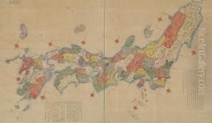
Nagakubo Sekisui Paintings
Nagakubo Sekisui was a Japanese cartographer and geographer during the Edo period, which is also known as the Tokugawa era, spanning from 1603 to 1868. Born in the year 1717, Sekisui’s work came at a time when Japan was relatively isolated from the rest of the world under the sakoku policy, which heavily restricted foreign influence and travel.
Sekisui is most noted for his work in the field of cartography, particularly for his revision of the map of Japan initially created by the Japanese mapmaker Matsumura Kenzan. Sekisui's revised map, known as 'Kaisei Nihon Yochi Rotei Zenzu,' which translates to 'Revised Complete Map of Japan’s Mountains and Rivers,' was completed in 1779. It was a significant contribution to the cartography of Japan and was considered one of the most detailed and accurate maps of the time. This map was later used by the Tokugawa shogunate, the feudal military government of Japan, as an authoritative geographical resource.
Sekisui's work on the map incorporated a range of geographical information, including mountains, rivers, and provincial boundaries. His attention to detail and accuracy was a reflection of the scholarly rigor and the practical needs of Edo-period governance and travel. Despite the isolationist policies of Japan during this time, Sekisui and other scholars like him were able to develop an understanding of geography that contributed to the groundwork for future Japanese cartographic endeavors.
Throughout his life, Nagakubo Sekisui also engaged in scholarly pursuits, studying under the Confucian scholar Ogyu Sorai, one of the most influential thinkers of the 18th century in Japan. This education likely influenced his meticulous approach to cartography.
Sekisui passed away in 1801, having made a lasting impact on the field of Japanese geography and cartography. His maps continued to be used and referenced for many years after his death, and his legacy is that of a pioneering figure in the mapping of Japan.
