The late seventeenth and early eighteenth centuries marked a pivotal era in the history of English cartography. It was a time of burgeoning national confidence, colonial expansion, and a growing thirst for geographical knowledge. Amidst this dynamic environment, Robert Morden (circa 1650–1703) emerged as one of England's most significant and prolific mapmakers, engravers, and publishers. His work not only reflected the cartographic trends of his time but also introduced innovations that would influence mapmaking for decades to come. Though often beset by financial difficulties, Morden's dedication to his craft left an indelible mark on how the British Isles, the American colonies, and the wider world were visualized and understood.
Early Life and Apprenticeship in a Changing Craft
Robert Morden's precise birthdate remains approximate, generally placed around 1650. He is believed to have hailed from the north of England, possibly from the West Riding of Yorkshire. This regional origin is noteworthy, as London was already the dominant center for publishing and the arts, but provincial talents often sought their fortunes in the capital. Morden's foundational training came under the tutelage of Joseph Moxon (1627–1691) in York. Moxon was a remarkable figure in his own right – a printer, publisher, hydrographer to King Charles II, and a maker of maps, globes, and mathematical instruments.
Moxon's diverse expertise would have provided Morden with a comprehensive education in the various facets of map production, from surveying principles and draughtsmanship to the intricate art of copperplate engraving and the business of publishing. Morden was granted his freedom, likely from the Worshipful Company of Weavers to which Moxon also belonged (as there was no specific guild for mapmakers then, craftsmen joined related guilds), around 1666. This marked his official entry into the trade as a qualified craftsman, ready to establish his own practice. He eventually set up his premises in London, the heart of the English map trade, at the sign of the "Atlas" in New Cheapside and later in Cornhill.
The Cartographic Landscape of Late 17th Century England
When Morden began his career, English cartography was in a state of transition. For much of the 17th century, the Dutch had dominated the European map market. Lavish atlases by cartographers like Joan Blaeu (1596–1673), Johannes Janssonius (1588–1664), and Frederik de Wit (c. 1629/30–1706) set the standard for quality and artistry. English mapmakers were striving to establish their own distinct tradition and reduce reliance on Dutch imports.
Pioneering figures like John Ogilby (1600–1676) had already made significant contributions with his groundbreaking strip road maps in Britannia, Volume the First (1675), which meticulously detailed the principal roads of England and Wales. John Seller (c. 1632–1697), as Hydrographer to the King, was working to produce English sea charts to rival Dutch nautical atlases like the "Waggoners." These efforts signaled a growing ambition within the English mapmaking community, a community Morden was poised to join and significantly shape. The demand for maps was increasing, driven by trade, warfare, colonial administration, and a general intellectual curiosity fostered by the Royal Society and the Enlightenment spirit.
Morden's Emergence and Early Collaborations
Robert Morden quickly established himself as a skilled and industrious mapmaker. His early career was characterized by numerous collaborations, a common practice in the capital-intensive and skill-diverse field of map publishing. One of his earliest significant partnerships was with William Berry (fl. 1669–1708), another prominent London mapmaker and seller. As early as 1675, Morden and Berry were working together, and in 1677, they jointly petitioned the Attorney General for a patent or license to produce "general and particular maps of all parts of the world, alphabetically and methodically." While this grand project for a comprehensive world atlas under royal patent did not fully materialize in the way they might have envisioned, it demonstrated their ambition.
Their collaboration did yield notable works, including a large two-sheet New Map of the Water and Earth (1676), based on Mercator's projection, and a later version in 1698. These world maps were attempts to provide an English alternative to the dominant Dutch productions. Morden also worked closely with Philip Lea (c. 1660–1700), a highly successful map publisher who had, for a time, been an apprentice or associate in Morden's workshop. Lea would go on to become a major figure in his own right, often reissuing and adapting maps by Morden and others.
Landmark Works and Cartographic Innovations
Robert Morden's reputation rests on a substantial body of work, characterized by its clarity, detail, and often, innovative features. His output ranged from individual county maps and national maps to comprehensive atlases and geographical texts.
Geography Rectified, or a Description of the World
First published in 1680, Geography Rectified became one of Morden's most enduringly popular works, seeing several editions (1688, 1693, 1700). This was more than just an atlas; it was a compact geographical encyclopedia. The book provided textual descriptions of the kingdoms, provinces, cities, and other features of the world, accompanied by a remarkable series of seventy-eight miniature maps. These small maps, while not offering extensive detail, made geographical information accessible to a wider audience and demonstrated Morden's skill in conveying information concisely. The success of Geography Rectified highlighted the growing public appetite for geographical knowledge presented in an organized and affordable format.
County Maps and Camden's Britannia
Perhaps Morden's most celebrated contribution was his set of county maps for the 1695 edition of William Camden's Britannia. Originally published in Latin in 1586, Camden's Britannia was a seminal topographical and historical survey of Great Britain. The 1695 edition, translated and updated by Edmund Gibson, required a new set of maps, and Morden was commissioned for this prestigious task. This was a significant undertaking, involving the creation of fifty county maps for England and Wales.
Morden's maps for Camden's Britannia were a marked improvement on many earlier county map series, such as those by Christopher Saxton (c. 1540–c. 1610) and John Speed (1551/2–1629). While Saxton's maps were foundational and Speed's were highly decorative and popular, Morden's maps introduced several practical innovations. Notably, he was among the first, following Ogilby's lead, to consistently include roads on county maps, a feature of immense practical value in an era of increasing travel. He also pioneered the use of different scales for different counties, categorizing them as "Large," "Middle," and "Small." This allowed for a more appropriate level of detail depending on the geographical extent of the county, a departure from the often-uniform scale of earlier atlases. His Rutlandshire 1st Edition (1695), part of this series, is a prime example, clearly showing roads and employing his scale system. The maps also included symbols for religious centers, battle sites, and other features of interest.
The success of these county maps led to their reissue in various forms, sometimes as a separate atlas often referred to as Morden's Britannia or The New Description and State of England. His Britannia Saxonica, also published around 1695, focused on the Anglo-Saxon kingdoms and further showcased his historical-cartographic interests. These maps remained influential for many years, with later cartographers like Herman Moll and Emanuel Bowen drawing upon them.
Maps of the British Isles
Beyond the county maps, Morden produced several important general maps of the British Isles. His A New Map of England and Wales, independently published in 1690, was a significant single-sheet map offering a comprehensive overview. He also collaborated with Christopher Brown (fl. c. 1680-1710) on A New Map of Ireland (1691). This map was particularly noteworthy as it was based on the groundbreaking surveys conducted by Sir William Petty (1623–1687) during the Cromwellian era (the "Down Survey"). Petty's work represented a more scientific approach to land surveying, and Morden and Brown's map helped to disseminate this improved geographical understanding of Ireland. He also produced Historical Maps of England and Ireland, which depicted invasions and significant conflicts, catering to an interest in military history.
Charting the Americas
The late 17th century was a period of intense English colonial activity in North America, and Morden contributed to mapping these expanding territories. He collaborated with prominent hydrographer John Thornton (1641–1708) and Philip Lea on several important American maps. Among these was A New Map of the English Empire in the Continent of America (1685), which depicted regions from New England south to Carolina. Another significant work was their New Map of New England, New Jersey and Pensilvania (first state likely around 1688, though often dated to his Geography Rectified editions).
Their map A New Map of Carolina (circa 1695), also produced with Thornton and Lea, was based on earlier work by Joel Gascoyne (c. 1650–1705/6), a noted surveyor who had worked in Carolina. These maps were crucial for colonial administration, land speculation, and for providing information to potential settlers. They represent some of the earliest detailed English attempts to chart these rapidly developing regions. The First Plan of New York Harbor (1685), another collaboration with Thornton and Lea, underscores their engagement with the strategically important colonial ports.
London in Focus
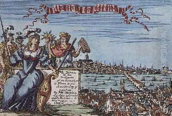
As a London-based craftsman, Morden also turned his attention to mapping the rapidly growing metropolis. He collaborated with Philip Lea on An Actual Survey of London, Westminster and Southwark (circa 1690), a detailed plan of the city. Around 1700, he produced A Prospect of London, which offered panoramic views and plans of the capital, including key landmarks like St. Paul's Cathedral. These maps are invaluable historical documents, capturing the urban landscape of London at the turn of the 18th century.
Artistic Style and Cartographic Techniques
Robert Morden's maps are generally characterized by their clarity and functional design, though they were not without decorative elements. The primary technique used was copperplate engraving, which allowed for fine lines and detailed text. Most of his maps were designed to be hand-colored, typically with outline color for boundaries and washes for larger areas like parks or seas, enhancing their visual appeal and legibility.
His cartouches (the decorative frames around titles and other information) were usually in the baroque style prevalent at the time, often incorporating allegorical figures, coats of arms, or scenes relevant to the mapped area, though perhaps less flamboyant than some of his Dutch contemporaries or English predecessors like John Speed. Morden's emphasis was often on the accurate and clear presentation of geographical information.
Key stylistic and technical features include:
Clarity of Engraving: His lines were generally clean and precise.
Inclusion of Roads: A significant practical feature, especially in his county maps.
Variable Scales: His innovative use of "Large," "Middle," and "Small" scales for county maps.
Longitude and Latitude: He included graticules, and notably, on some maps, marked longitude from London (a practice becoming more common for English mapmakers) and sometimes included Roman numerals to indicate time differences, a useful feature for travelers.
Mileage Scales: Often included, aiding in the calculation of distances.
Rich Topographical Detail: Depiction of towns, villages, rivers, hills (often using hachures or molehill symbols), forests, and important estates.
While Morden aimed for accuracy based on the best available surveys, it's important to remember that cartography in this period was still an evolving science. Surveying methods were improving but not yet standardized to modern levels of precision. Morden, like his contemporaries, relied on existing sources, compiling and re-engraving information, and adding his own updates and stylistic interpretations.
Collaborations, Competition, and Contemporaries
The map trade in London was a close-knit and sometimes competitive world. Morden's career is a testament to the importance of collaboration. His partnerships with William Berry, Philip Lea, John Thornton, and Christopher Brown were crucial to the production and dissemination of his extensive catalog of maps.
He also faced competition. Herman Moll (1654–1732), another highly influential cartographer active in London (originally from Germany or the Netherlands), became a dominant figure in the early 18th century. There was considerable overlap in their work; Moll, for instance, produced his own set of county maps for a rival edition of Camden's Britannia and was known to "borrow" heavily from the work of others, including Morden's. While Moll often claimed to have "corrected" earlier maps, the lineage of Morden's innovations can often be traced in Moll's output. This practice of copying, adapting, and reissuing maps was common and, in the absence of strong copyright laws as we know them today, a standard feature of the trade.
Other notable figures in the English map trade during or overlapping Morden's time included:
John Seller: As mentioned, Hydrographer to the King, focused on sea charts.
Richard Blome (1635-1705): A publisher who produced county maps, though generally considered of lesser quality than Morden's.
John Senex (1678–1740): Began his career towards the end of Morden's life and became a leading mapmaker in the next generation.
Charles Price (fl. c. 1697-1733): Another contemporary mapmaker and publisher.
Later, figures like Emanuel Bowen (1694–1767) and Thomas Kitchin (1718–1784), who collaborated on works like Speed's Maps Epitomiz'd and Atlas Anglicanus (Thomas Bowen), would build upon the foundations laid by Morden and his generation, sometimes re-using or re-engraving earlier plates.
Financial Struggles and Professional Realities
Despite his prolific output and the evident quality of his work, Robert Morden appears to have faced persistent financial difficulties throughout his career. He often complained of a lack of recognition for his talents and the poverty that constrained his ambitions. The map trade was capital-intensive, requiring significant upfront investment in copperplates, paper, and skilled labor for engraving and printing. Competition was fierce, and profits could be uncertain.
His reliance on partnerships was likely, in part, a strategy to share costs and risks. The financial pressures may also have driven his high productivity, as he sought to generate income through a steady stream of new maps and revised editions. His complaints, recorded in some of his prefaces or dedications, offer a poignant glimpse into the often-precarious existence of even skilled artisans in this period. This economic reality underscores the entrepreneurial spirit required to succeed, or even survive, in the London publishing world.
Legacy and Art Historical Significance
Robert Morden died in 1703. His son, also named Robert (and sometimes confused with him), and his former apprentice Thomas Cockerill, continued his business for a time. Morden's maps, however, had a much longer lifespan. His county maps, in particular, were reissued for many years, sometimes with minor alterations, well into the mid-18th century. Their clarity and utility ensured their continued relevance for travelers, administrators, and the geographically curious.
In the annals of art history, particularly the specialized field of cartographic history, Robert Morden is regarded as a key figure in the maturation of English mapmaking. His contributions include:
Popularizing County Maps: His maps for Camden's Britannia set a new standard for English county cartography.
Innovations in Content: The consistent inclusion of roads and the use of variable scales were significant advancements.
Mapping the Colonies: His maps of North America provided vital, if sometimes imperfect, representations of the expanding English colonial presence.
Dissemination of Geographical Knowledge: Through works like Geography Rectified, he made geographical information more accessible to a broader public.
Bridging Traditions: He successfully combined the decorative appeal expected of maps in his era with an increasing emphasis on accuracy and practical utility, helping to bridge the gap between the more pictorial styles of earlier cartography and the more scientific approaches that would develop in the 18th century with figures like John Rocque or William Faden.
Morden's career reflects the dynamism and challenges of the English map trade at a crucial juncture. He was an innovator, a skilled craftsman, and a prolific publisher whose work significantly enriched the geographical understanding of his time. Though he may not have achieved the financial success he desired, his cartographic legacy is undeniable, his maps remaining valuable historical documents and sought-after collector's items that speak to the skill and artistry of late Stuart England. His influence can be seen in the work of subsequent generations of mapmakers, solidifying his place as a pioneer in the story of British cartography.